
Foursquare recently joined the Open Geospatial Consortium (OGC) to support the definition and implementation of new open file formats for big geospatial data.
The first concrete deliverable of this effort, OGC’s Web Map Service (WMS) protocol is now supported in Foursquare Studio, giving users the ability to access vast amounts of geospatial map data from a global range of WMS services.
Additionally, in the spirit of interoperability, Foursquare has made the source code that powers the new WMSLayer in Foursquare Studio available as open source. Under permissive MIT licensing that supports usage in other commercial products, the WMSLayer can also be found in the deck.gl and loaders.gl frameworks.
Finally, the new WMS feature is available to all Foursquare customer tiers, including free community users. This means that anyone can sign up for a Foursquare account and test out the feature at no cost.
About WMS
With an original specification published in 2000 by the OGC, WMS has matured into one of the most robust and widespread standardized protocols for serving map images over the Internet.
By incorporating support for WMS, Foursquare Studio enables traditional GIS users to import their existing WMS datasets into Studio, and new geospatial data science practitioners to leverage current WMS data services for their use cases.
A range of WMS services are available globally. The table below lists some examples of the WMS data that is now available.
| WMS Service | Description |
OpenStreetMap WMS | OpenStreetMap rendered, updated weekly, covering the entire globe. Copyright OpenStreetMap.Example: Chicago Loop. |
NOAA Composite Reflectivity WMS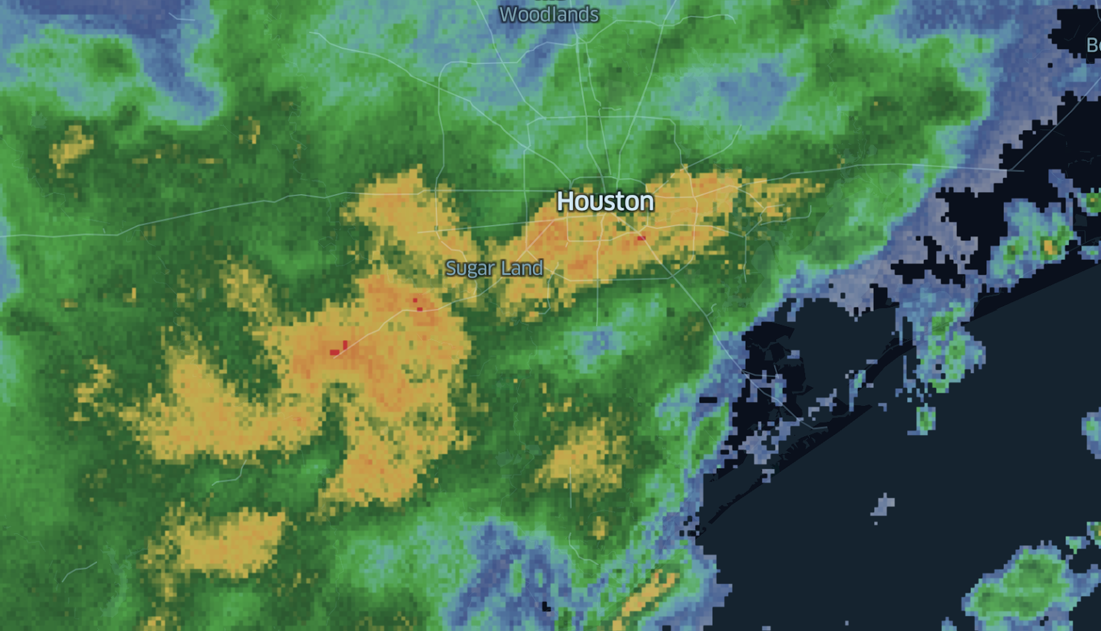 | Radar precipitation data covering the contiguous US. Quality Controlled 1km x 1km CONUS Radar Composite Reflectivity. This data is provided by the Multi-Radar-Multi-Sensor (MRMS) algorithm.Example: Storm over Houston, Texas. |
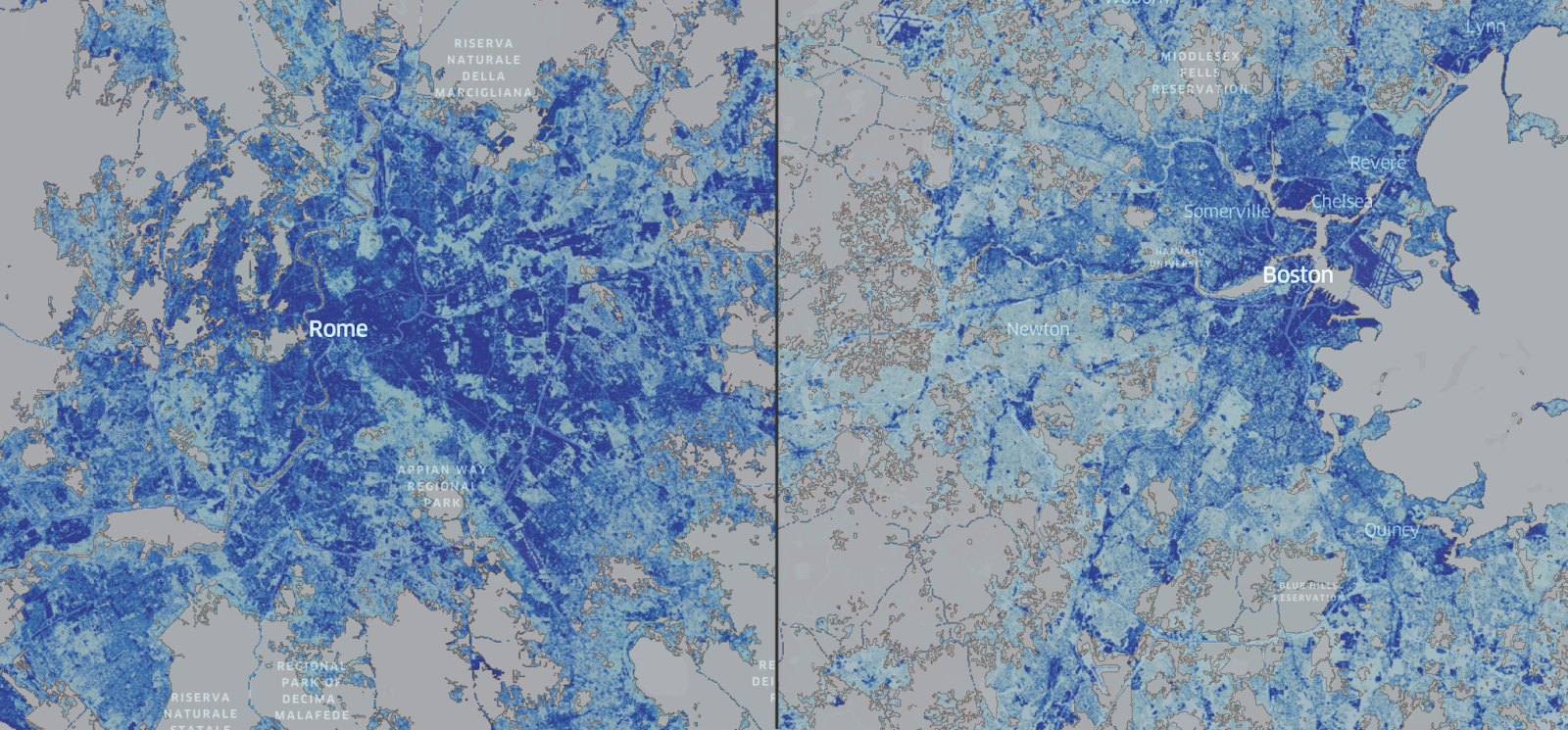
NASA Global Imagery Browse Services for EOSDIS | Over 1,000 NASA satellite imagery products, covering every part of the world. Most imagery is updated daily—available within a few hours after satellite observation, and some products span almost 30 years.Example: Impervious surfaces in the Los Angeles Metropolitan area. |
Hybrid Analytics with WMS
Foursquare Studio is designed to let users easily bring different geospatial data sources together and seamlessly combine them. The WMS feature in Foursquare Studio aims to enrich the experience of exploring WMS services, enabling you to combine WMS data with your existing analytic datasets by blending WMS layers with your other layers.
And as always, as soon as you have reached insights or results that others can benefit from, you can publish or share your project with a single click and without ever leaving your browser.
Using WMS in Foursquare Studio
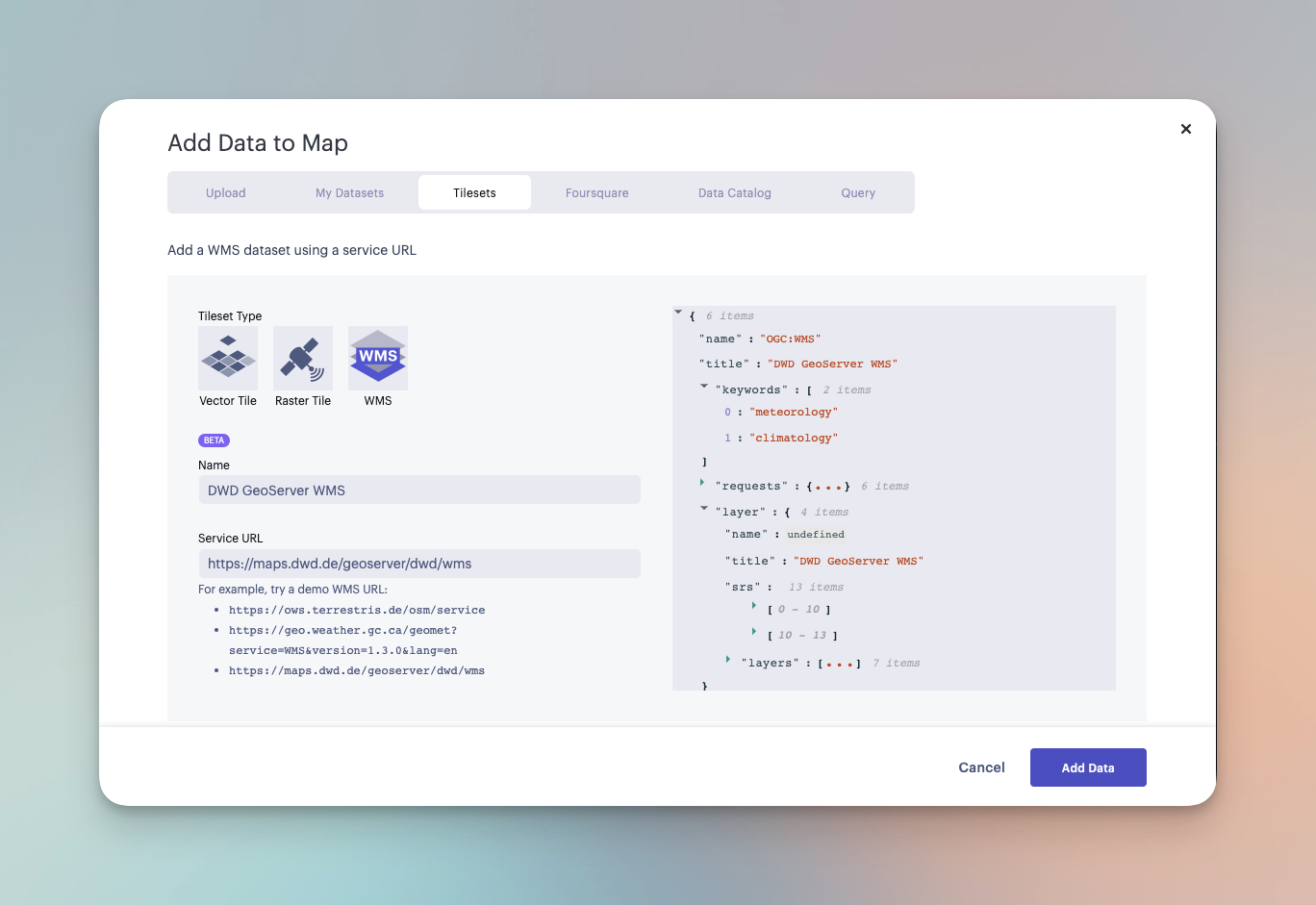
To use a WMS service, the first step is to obtain the URL to that service and register it as a “WMS dataset” in Foursquare Studio. Once this dataset has been created, it can be shared with other users in our organization and reused directly in other maps.
Once a WMS data source has been added to a map, a WMSLayer will be auto-created, and users are free to select any combination of “map layers” exposed by the WMS service.
Naturally, the WMS data rendering interacts seamlessly with the existing layered rendering model in Foursquare Studio, and the user can opt to include several layers from the same WMS source, and then combine them with layers from other data sources.
The video below shows hillshade, precipitation, and county boundary layers being blended via opacity sliders, then rearranged.
Blending and rearranging WMS layers in Studio.Example
Explore the example below! The three WMS datasets listed above are available for you to work with.
Open Source Commitment
Foursquare is a founding member of the Linux Foundation and OpenJS Foundation’s Open Visualization subgroup, plus is a lead contributor to the foundation’s major geospatial open-source frameworks.
The WMS implementation that powers the new Foursquare Studio WMS feature was developed in open-source form in the loaders.gl and deck.gl frameworks.
These are just the latest contributions in Foursquare’s long-standing and ongoing commitment to geospatial open source.
Moving Forward
Foursquare plans to continue to improve open standards support (e.g. we are actively contributing to GeoParquet), so keep an eye out for new announcements.
The Takeaway
By supporting standards-based geographic formats such as WMS in our tools, Foursquare enables increased interoperability and flexibility in the geospatial tooling industry. We are empowering users to seamlessly leverage existing geospatial datasets within our advanced analytics and visualization platform, and layering other geospatial datasets on top of standards-based formats. This ultimately provides more flexibility for users and further drives interoperability.


