Foursquare Studio has just received a significant update, now offering support for Google 3D Tiles, sunlight, shadows, and a comprehensive set of visual effects.
These new features represent a major step toward empowering geospatial designers to express their artistic vision in Foursquare Studio and bring the full power of their skills and creativity to the maps they create.

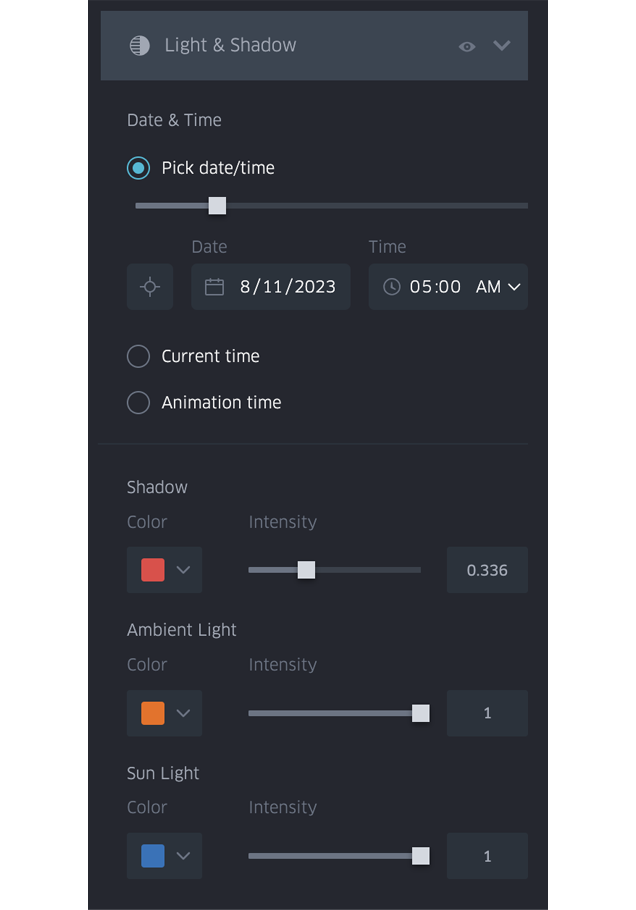
Shadow and Light
The new lighting system in Foursquare Studio lets users model real-world lighting conditions. The direction of light (the sun angle) is based on astronomically correct calculations of the sun’s position at your map’s center location and the selected date and time.
Fine-tuned shadows and lighting can also provide dramatic visual effects that increase a map’s visual appeal and impact.
When dealing with abstract three-dimensional visualizations, incorporating lighting can be highly beneficial, as it introduces visual cues that provide an easier understanding of the scene’s structure for viewers.
Astronomically correct lighting allows users to see how different buildings shade each other during different times of day and year.The new lights and shadow effect is highly configurable. Sunlight direction is based on astronomical calculations for time and date, and the time can be set to a specific date and time, or the viewer’s current date and time, or set to track the map’s primary time field during animation playback.
3D Tile Layer
Foursquare Studio now provides support for 3D Tile datasets, in the form of:
- A new Tiled Layer dataset type.
- A new 3D Tile Layer that allows you to include massive 3D datasets in your maps, including the new Google 3D Tiles.
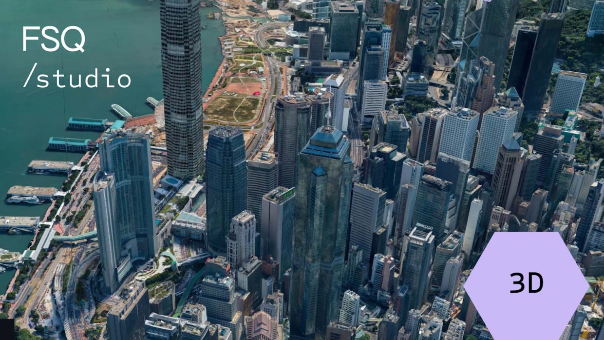
Massive Photorealistic 3D Visualizations
Data formats and rendering techniques for massive 3D datasets have developed rapidly over the last 5-10 years, spearheaded by impressive programs such as the Cesium-driven 3D Tiles OGC standard and the Esri-driven I3S OGC standard.
However, the lack of easily accessible and affordable global 3D datasets has held back the usage of these amazing technologies and to some extent relegated them to niche applications.
Enter Google 3D Tiles
The launch of Google 3D Tiles at Google I/O 2023 changed the game overnight. Detailed photorealistic renderings of hundreds of cities across the globe are currently freely available as part of the Google Maps API.
The Digital Twins Use Case
For geospatial data, massive photorealistic 3D data allows businesses to model and visualize their operations in a realistic setting that mirrors (or “twins”) the real world. Instead of overlaying their data points over a flat, muted basemap, data scientists can now see that data in the context of a realistic city model.
For example, data scientists at a ride sharing company can investigate bottlenecks in the efficiency of their operations overlaid over the actual 3D geography of the city they are operating in, making it easier to understand what the driver’s and customers’ experiences were like and how the environment might be affecting trips.
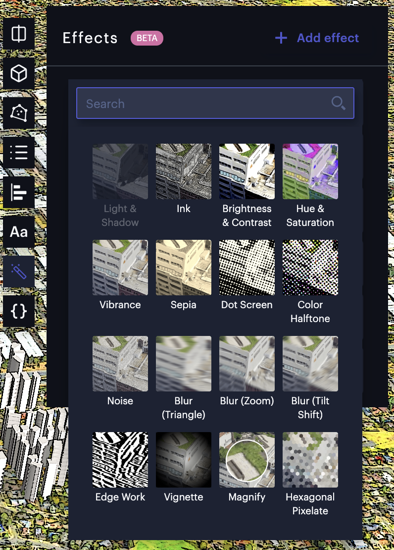
Visual Effects
Finally, Foursquare Studio now includes a wide selection of visual post-processing effects that target artistic map making.
These image processing algorithms are performed on all pixels in the image in order to fine tune the visualization, with effects including brightness, contrast, and vibrance.

Artistic Map Making
We know that many geospatial analysts using Foursquare Studio to create maps today care about the design elements of their maps. Their maps are often created to convey or support a message, or tell a story about their data.
The addition of post-processing effects takes the artistic freedom of Studio to the next level. The variations of map visualizations that can be achieved are almost limitless.
While the new effects are dramatic examples of designer-focused features, Foursquare has consistently been adding designer-friendly features to Studio, including:
- Detailed fine grained color and color scale controls
- Text and annotation support
- Legend enhancements
Photoshop for Map Makers
The new effects system is designed to feel familiar to users who have worked with post-processing of photos in applications like Photoshop.
Such applications provide a range of image processing filters that can be layered to achieve composite effects and are used to highlight the strengths of a photo and increase its visual impact, and many of the standard image processing filters are offered as part of the new effects system.
Foursquare believes that geospatial analysts creating visualizations intended to convey a message or an insight can benefit from the same techniques. Just as these effects enhance photos, they can also make maps more visually engaging and significantly increase the effectiveness of the map’s message.
Post-processing in external tools
Naturally, the new effects system does not provide all the capabilities of the latest generation of applications like Photoshop. In those cases, it’s possible to export a Foursquare Studio map as an image and process it separately in dedicated image processing applications.
However, our team recommends exporting only as the final processing step for map images, as it requires more effort. When work on the map is still taking place, it is encouraged to stay within Foursquare Studio and experiment with effects and other features in parallel.
Applying Effects on Video and Interactive Visualizations
The new built-in effects also work automatically with interactive and animated visualizations.
The new effects in Foursquare Studio are applied instantly by the GPU on each rendered image frame, meaning that they are always visible, even during performance intensive-operations such as animated playback and video export.
Developing Applications with Effects and 3D Tiles
Foursquare Studio can be a powerful visualization and analytics component in the development of the user’s own geospatial applications.
Naturally, all the new artistic capabilities including both the effect system and the 3D tiles support are available to application developers.
Foursquare provides an extensive Map SDK for embedding and controlling Studio maps, and also a meticulously documented map configuration format that allows maps to be programmatically generated and modified by developers.
- Map SDK for Python Notebooks and JavaScript – New functions allow applications to easily add and remove effects from embedded maps, Python notebooks, etc.
foursquareMap.addEffect({
    type: ‘ink’,
    parameters: {
	{strength: 0.5}
    }
})
- Studio Map Configuration – The JSON subschema for the new effects is documented as part of the Map Configuration, allowing map effects to be added, deleted and modified programmatically.
     "effects": [
        {
          "id": "...",
          "isEnabled": true,
          "type": "ink",
          "parameters": {
            "strength": 0.25
          }
        }
      ],
- Configuration Editor – Effects can be specified and edited programmatically in a syntax-aware text editor, just like layers, charts, filters, etc.

Effects and 3D Tiles for Data Scientists
Data scientists who prefer working with Python notebooks instead of the Foursquare Studio UI are also catered to. The Python version of the Map SDK can be seamlessly integrated into various Python notebooks, offering the same level of programmatic control over effects and 3D tiles as its JavaScript counterpart in the Map SDK.
What’s next?
As powerful as the newly launched 3D visualization and advanced post-processing features are, Foursquare Studio has just begun scratching the surface of what’s possible for geospatial visualization.
As such, we already have a number of improvements in mind, including:
- Polish the current features so that we can remove the beta tags.
- Add additional post-processing effects.
- Offer users more advanced control of how post-processing effects are applied.
- More optimized rendering of 3D tiles source data
- Integration with additional 3D tile services.
How far we take photorealistic visualization depends on what our users and customers (i.e., you!) want. We invite you to join our discussion forums and let us know what you would like to see.
If you are excited to take your geospatial visualizations to the next level with 3D Tiles and post-processing techniques, it takes mere seconds to sign up for a free account and start using Foursquare Studio.


