We have something spatial to announce: Hex Tiles, a next-generation tiling system that gives data scientists the ability to easily unify diverse spatial datasets, conduct on-the-fly analytics, and quickly visualize and explore big data on a planetary scale. What’s more, this can all be done in a matter of minutes and within your browser through the Unfolded Platform.
What Makes Hex Tiles So Special
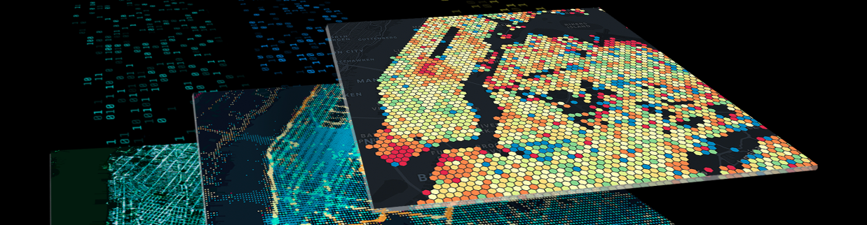
Leveraging the power of H3, an open-source, hierarchical discrete global grid system that breaks up the world into hexagonal cells, Hex Tiles offers significant advantages for performing large-scale geospatial data visualization and analytics.
One of its main advantages is the ability to address the problem of unification. Spatial data, in particular, comes in many different shapes, forms, types and sizes making it a difficult and time-consuming process to join data for visualization, exploration and analysis. Using the Hex Tile system, you can quickly and easily ingest diverse spatial datasets and transform them into Hex Tiles. This not only simplifies the process of unifying data and allows users to perform more efficient analytics, but provides the opportunity for greater data enrichment.
Furthermore, compared to existing formats like vector or raster tiles, Hex Tiles has a proprietary spatiotemporal analytics tile format that is optimized for temporal analysis. It can encode data more efficiently than vector tiles and unlike raster tiles and can be used for client-side analytics. Its unique format allows data to be used in a tabular form – the commonly used data format for analytics and machine learning.
Scale, speed, and simplicity – Turning days of work into mere minutes.
Let’s say you want to understand how hurricane season is affecting traffic patterns to your restaurant chain on the East Coast. You’d need several datasets, such as Places POI data, Visits foot traffic data, weather, traffic and census data, to explore this question and draw an accurate conclusion.
Before Hex Tiles, prepping and juggling all of these large, disparate datasets would be tricky, time-consuming, and would require additional coding and technology. Indeed, you would need days to get this done.
With Hex Tiles, however, the data scientist (or team) could leverage their own computer’s processing power and just one platform to seamlessly enrich, visualize, and explore the data.
How does it work?
Hex Tiles can transfer large-scale geospatial data over the web in a tiled, tabular, gridded format, allowing users to process spatial data at great scale, easily unify or join diverse datasets, and ultimately perform greater analysis. The best part? Anyone can visualize and explore entire planetary-scale datasets fluidly and in crisp detail without having to code.
Using Hex Tiles you can process hundreds of millions of rows of data in parallel, giving it the ability to support instant visualization and fluid exploration of data at interactive speeds. In short, you can easily work with any area of interest on the map without concerns about the size of your data.
A few ways to put Hex Tiles to work.
Site selection: Shops and service providers often face the classic problem of determining their next location to invest in. Hex Tiles are ideal for supporting this problem of suitability analysis by suggesting the ideal sites based on patterns unearthed from demographic data, distances to other points of interests (POIs), human footprint and movement, and other chosen datasets. With access to multiple disparate datasets, businesses can make more informed decisions quicker than ever.
Similarity analysis: A business might also be looking to expand and replicate the success of an existing store or food service location. Hex Tiles makes this process seamless. The system can identify other locations that may be similar to current sites based on select criteria such as demographics and land cover. With Unfolded’s Python Map SDK and current data on the clients’ business location, users can easily receive attributes – think customer demographics, land cover and movement – for the areas of interest around their stores.
Get started with Hex Tiles.
Try Hex Tiles for free. Log in to Unfolded Studio to access the new Hex Tile datasets in the Data Catalog, ready for data enrichment, extraction and exploration.
See how Hex Tiles can help you with large-scale data analysis and visualization. Contact us for a demo of Unfolded’s Enterprise features and learn how you can convert your own datasets to Hex Tiles to do site selection, suitability analysis and more.
Related content


