Foursquare has been at the forefront of location-based technology for over fifteen years. Through our consumer apps, SDKs, software, and services, we have developed a comprehensive understanding of real-world locations and the human mobility patterns associated with them. We harness this geospatial intelligence to serve the world’s largest businesses through two primary product categories: specialized data products for developers and data scientists, such as Places (our points-of-interest dataset), and vertical solutions for marketers in the advertising domain, such as Attribution & Targeting.
With their success, these offerings revealed a significant opportunity for us to further amplify the reach and impact of our unique understanding of the real world. Though rich in insights, our specialized data products often required specific tools, expertise, and integration with other datasets to unlock their full potential, limiting their reach to businesses with dedicated geospatial data science teams. Meanwhile, our vertical solutions demonstrated a different path forward – showing how location intelligence could be made accessible to non-technical teams, as marketing professionals without geospatial expertise can successfully leverage our offerings to drive advertising ROI. However, the specialized nature of these offerings constrained their applicability to other domains. With these learnings, we were driven to develop a new platform that would increase the value of Foursquare’s geospatial intelligence and make it accessible to a broader set of customers.
Today, we are excited to release the Foursquare Geospatial Intelligence Platform in beta, our first step towards democratizing access to geospatial intelligence. Our platform brings together new and existing Foursquare technology, data, and software into a unified, end-to-end experience to solve business challenges with geospatial intelligence. Built on three pillars – connected datasets that simplify complex data integration (FSQ Graph), specialized compute engine packaged with Foursquare algorithms that power advanced geospatial analytics (FSQ Database), and intuitive visualization that brings insights to life (FSQ Studio) – our platform enables organizations to derive location-based insights without deep geospatial expertise.
We specifically designed the Foursquare Geospatial Intelligence Platform for data analysts, key enablers of data-driven decisions across organizations. Through the platform, analysts can immediately query our enterprise-grade Places and Movements datasets alongside complementary datasets, leverage GPU-accelerated spatial algorithms, and create interactive visualizations – all through familiar SQL. Whether analyzing trade areas, understanding consumer patterns, or optimizing site selection, analysts can now unlock unique insights in hours instead of months (if at all.)
Let’s dive into the journey that led to the creation of this platform. We’ll share our hypotheses, the approach we took, and the innovations we’ve employed to achieve this goal.
Understanding the Barriers to Geospatial Intelligence
While geospatial data has become critical for business decisions, enterprises struggle to unlock its value. Even organizations with sophisticated data science teams require months to integrate and extract insights from geospatial datasets. The core challenge lies in combining multiple spatial datasets — a complexity that manifests in three key areas:
- Lack of standardized identifiers to join datasets: The absence of universal location identifiers creates significant challenges in joining different datasets. Consider a retail analytics scenario: while our Places database identifies a restaurant through address, geographic coordinates, and a unique identifier, transaction records from payment processors typically contain partial information like “SPEEDWAY 09582 CINCINNATI” — combining merchant name, store ID, and location. To accurately link these records to derive value, organizations must develop sophisticated matching algorithms that factor in proximity, name similarity, and address variations.
- Data attached to varying spatial resolutions: Datasets frequently come at different geographic scales, complicating direct comparisons or integrations. Census data, for example, is typically aggregated at census block group level (generally containing 600-3,000 people), while business data might be at a postal code level. Since postal codes and census blocks, when represented as polygons, do not have a strict containment relationship, analyzing trends across these datasets requires sophisticated spatial aggregation or disaggregation techniques to bring all data to a common spatial resolution.
- Need for specialized spatiotemporal tooling: Modern location analytics demands processing capabilities beyond traditional databases. Analyses combine spatial operations (geometric calculations, point-in-polygon testing), temporal dynamics (high-frequency aggregations, seasonal patterns), and network analyses (routing, accessibility.) A retail expansion analysis, for example, requires processing thousands of trade areas, analyzing foot traffic patterns, and assessing network accessibility simultaneously. Even simple queries like “find growing competitors within walking distance” demand coordinated processing of spatial, temporal, and network characteristics at scale.
Breaking Down The Barriers: The Three Pillars of Our Platform
To address the complex challenges of geospatial analysis, we designed our platform around three essential requirements: 1) a comprehensive data foundation that combines our proprietary datasets with public sources and enables seamless integration of customer data; 2) specialized compute infrastructure for advanced spatial operations; and 3) sophisticated visualization capabilities that make complex insights immediately comprehensible. These requirements led us to create the three pillars of our Geospatial Intelligence Platform:
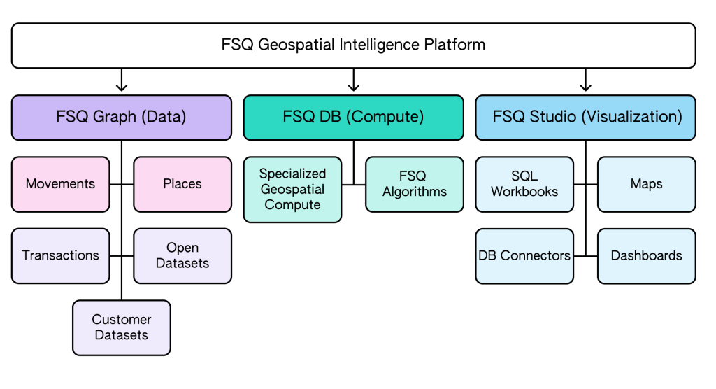
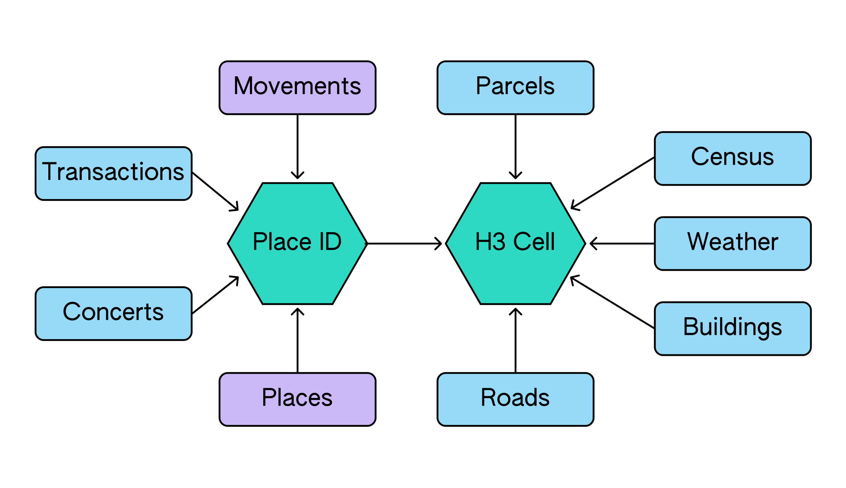
- FSQ Graph: At the heart of our platform lies a revolutionary data backbone that simplifies the complex task of spatial data integration. By standardizing on the open-source H3 hierarchical geospatial indexing system for spatial aggregation and FSQ Place IDs for point-of-interest mapping, FSQ Graph connects our industry-leading Places & Movements datasets with both public data sources and customer datasets. This elegant solution transforms the traditionally complex process of spatial data integration into a straightforward operation.
- FSQ Database: Our GPU-optimized compute layer brings the power of advanced geospatial analytics to the familiar world of SQL. By combining standard spatial operations with sophisticated algorithms for network analysis and spatiotemporal processing, FSQ DB enables analysts to execute complex location intelligence queries without specialized programming expertise.
- FSQ Studio: More than just a visualization tool, FSQ Studio serves as an interactive workspace where complex spatial analyses come to life. Built on industry-standard open-source frameworks kepler.gl and deck.gl, and enhanced with our proprietary features, Studio seamlessly transforms SQL queries into dynamic maps and dashboards. This powerful combination accelerates the insight discovery process, allowing analysts to explore spatial patterns and iterate on their analyses in real time.
While each of these pillars has existed independently at Foursquare, our platform now binds them together into a unified, seamless experience that streamlines how businesses integrate, compute, and analyze geospatial data.
Let’s go deeper into each of the three pillars of the Foursquare Geospatial Intelligence Platform.
FSQ Graph: Connecting the World’s Geospatial Data
Foursquare’s spatiotemporal understanding of the real world is encoded into two foundational datasets: Places and Movements. Together, these datasets are highly effective in helping businesses contextualize their decisions with real-world context, efficiently and cost-effectively. For example, a restaurant chain looking to expand can quickly identify promising neighborhoods for new locations by analyzing foot traffic patterns and nearby business types. This approach provides valuable insights without the need for time-consuming site visits or expensive market research. To strengthen our data layer, we invested in two key areas: 1) enhancing the systems supporting our foundational datasets to address current and future challenges in the location data space, and 2) building easy connectivity between our datasets and other open or proprietary geospatial datasets.
Foundational Datasets: Places & Movements
While Foursquare continues to be differentiated in how we leverage valuable first-party data from our apps, we’ve also re-architected our systems to incorporate and validate signals from high-quality third-party sources, adapting to the evolving data landscape.
Foursquare’s Places dataset is a comprehensive, global database of points of interest (POIs) that forms the foundation of our location intelligence offerings. The Places Engine, which generates this dataset, has evolved from two distinct systems: Foursquare’s legacy crowdsourcing approach and Factual’s digital intelligence method. The new Places Engine combines the strengths of both, leveraging AI agents alongside human input to create a self-governing system that continuously updates and verifies location data. This innovative approach addresses the “Digital Echo Chamber” effect, where inaccuracies in one digital source are replicated and amplified across multiple datasets, leading to widespread misinformation about locations. The Places Engine uses AI Reporting Agents to propose changes based on digital sources and AI Voting Agents to evaluate these proposals, working in tandem with human superusers. This system provides granular observability, allowing for detailed tracking of changes to each place record. The result is a highly accurate and fresh POI database that covers a wide range of locations, including those with minimal digital presence. You can find a more detailed description of the Places Engine in our blog post here.
While the Places dataset provides the spatial framework, our Movements dataset adds a crucial temporal dimension to our location intelligence. This dataset is a comprehensive representation of real-world location visits, built on a combination of first-party data from our consumer apps and carefully vetted third-party sources, where we mandate that all data shared with us is collected with required consumer notice and consent. We process data from these third-party sources and apply our proprietary stop-detection technology to identify clusters of GPS signals that indicate a certain dwell time at a specific location. This is followed by our snap-to-place algorithm, which is trained on ground truth generated from our consumer apps. This sophisticated approach allows us to precisely measure store visits in the physical world, even when GPS signals are imprecise or erroneous. We developed a new normalization technique that uses demographic and geographic weighting factors to extrapolate visits from our sample panel to accurately represent the broader population’s movement patterns. These normalized visits are then aggregated along different dimensions to allow our customers to glean insights without providing access to individual user-level visits. Additionally, as a part of our recent Attribution product innovations, we enhanced our understanding of the customer store visit to include purchase behaviors.
Connecting the Datasets: H3 & FSQ PlaceID
To amplify our data’s value when joined with other datasets, last year we developed FSQ Graph. This data backbone addresses the challenge of joining spatial datasets by standardizing on two join keys: H3 cells, cells in the H3 global hexagonal hierarchical spatial index, and FSQ Place IDs, unique identifiers for points-of-interest in our Places dataset. We’ve built tools that allow any dataset with spatial attributes to be indexed to H3 cells at a specified resolution or have a Foursquare PlaceID attached:
- H3 Indexing Pipeline: This pipeline enables any spatial datasets, including raster datasets, to be indexed to the H3 grid at a specified resolution. It provides pluggable strategies to distribute data tied to those geometries. For example, when disaggregating population data from census block groups to H3 cells at resolution 10 (approximately 0.1 km2 per cell), we offer two strategies: a simple approach that evenly distributes population across all cells within the census block, and a more sophisticated method that allocates population based on the proportion of residential and commercial building footprints within each cell.
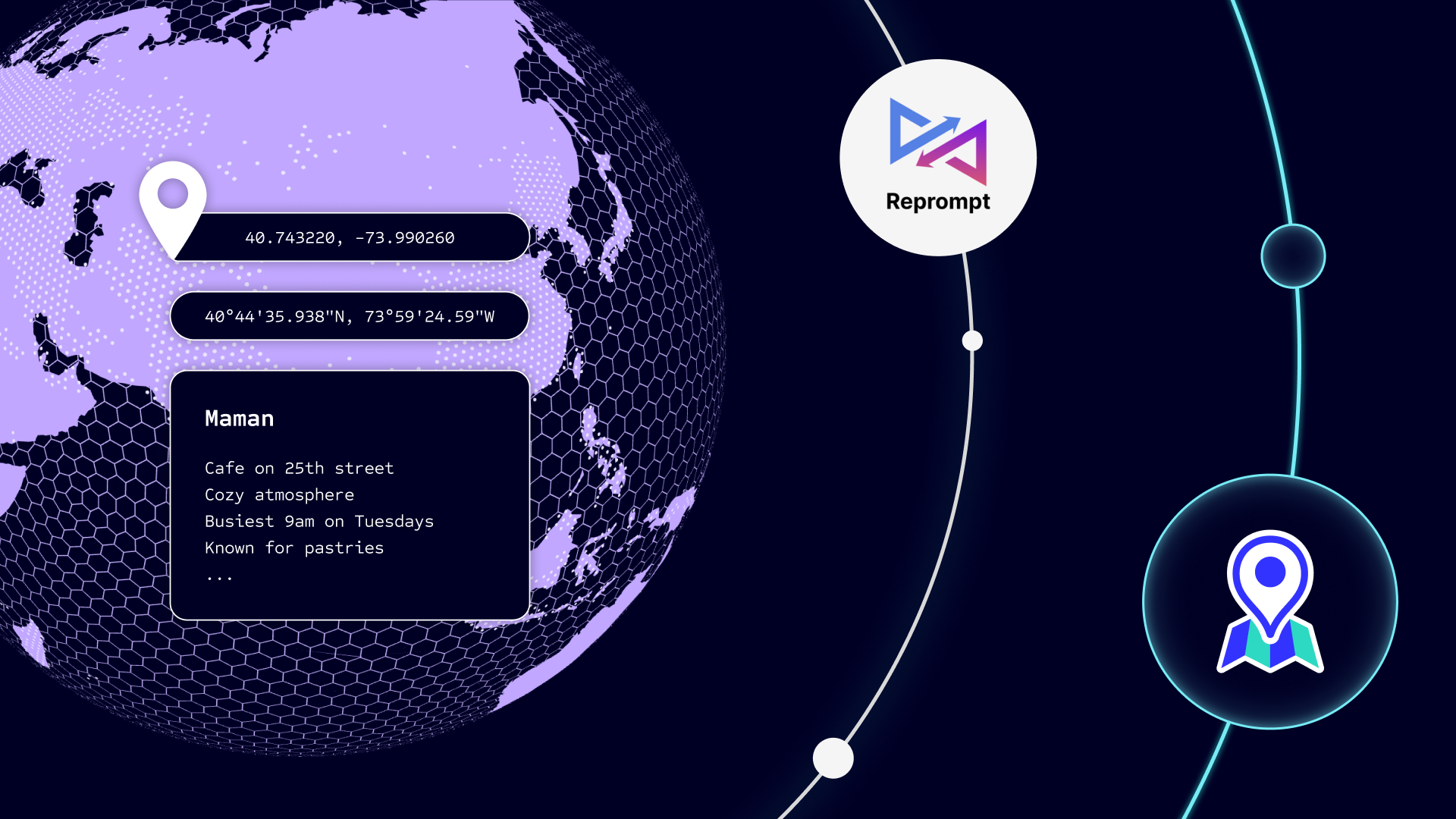
- Place Harmonization Pipeline: This pipeline enables diverse information, such as transactions, sports events, concerts, and merchant datasets that are typically associated with real-world places to be easily tied to Foursquare Places. By attaching information to a Foursquare Place, you not only benefit from additional data tied to that place, such as category and brand, but you can also map it back to an H3 cell at a specified resolution, facilitating joins with other spatial datasets.
Our H3 Indexing and Place Harmonization pipelines represent our approach to solving the complex problem of joining spatial datasets with ease, enabling more efficient and insightful geospatial analyses. Any new dataset that can be mapped back to a PlaceID or an H3 cell benefits from the rich information already connected in our FSQ Graph.
FSQ Database: Powering Geospatial Intelligence at Scale
Geospatial analytics encompasses a wide range of complex analyses that often require multiple technologies to derive meaningful insights. Common tasks include spatial indexing, point-in-polygon operations, distance calculations, spatial clustering, routing, and network analyses. More advanced applications involve integrating temporal data for spatiotemporal analysis, modeling intricate spatial relationships through knowledge graphs, and performing real-time analytics on large-scale datasets.
Traditional solutions struggle to address all these needs efficiently. While Python libraries with Spark offer flexibility for large datasets, they require specialized programming skills. PostGIS provides robust spatial operations, but can falter with very large datasets. Cloud data warehouses like Snowflake or BigQuery offer basic spatial operations but lack advanced geospatial algorithms out-of-the-box. Graph technologies, while powerful for network analyses, often struggle with the scale and complexity of geospatial data, especially when incorporating temporal elements. This fragmented landscape typically forces organizations to use multiple tools or develop custom solutions, increasing complexity and development time.
To address these challenges, we built the FSQ DB, a specialized geospatial compute layer that combines our location intelligence expertise with advanced algorithmic capabilities. To do so, we partnered with Kinetica, a real-time database that offers advanced spatiotemporal capabilities. Kinetica leverages the massive parallel processing capabilities of GPUs to accelerate geospatial computations. This approach allows for significantly faster processing of complex spatial queries and analytics on large datasets compared to traditional databases. Additionally, their native graph processing capabilities enable efficient modeling and querying of complex spatial relationships, all through standard SQL. Spatial operations that typically take several hours on traditional databases can now be completed within a couple of minutes, allowing Foursquare to push the boundaries of what’s possible with SQL in the geospatial domain.
With FSQ DB, we’ve packaged proprietary algorithms that leverage our connected datasets in the FSQ Graph to solve complex location intelligence challenges through simple SQL. For example, traditional trade area analysis requires combining multiple datasets (roads, POIs, demographics) with specialized routing engines – typically demanding significant engineering effort and Python expertise. Now, with FSQ DB, analysts can simply invoke our pre-built function in SQL, specifying appropriate parameters to achieve the same results. These GPU-accelerated algorithms deliver results in minutes rather than hours, enabling analysts to perform sophisticated location analytics without managing multiple tools or writing complex code.
FSQ Studio: Bringing Spatial Insights to Life
At the core of most big data use cases lies the desire to gain understanding and insights. Geospatial datasets have a distinct advantage in this regard – their inherent ability to be visualized at scale. While the human brain typically struggles to make sense of traditional graphs cluttered with excessive data, map-based visualizations allow us to discern patterns in large datasets with remarkable clarity. This capability enhances our analytical capacity by several orders of magnitude. The power of geospatial visualization extends far beyond basic mapping. Techniques often considered distracting in conventional charts, such as three-dimensional, true-colored renderings, add invaluable context to geospatial representations. These advanced visualizations provide a more intuitive understanding of spatial relationships, terrain, and other geographical features that might be crucial for analysis.
One of the challenges in visualizing geospatial data is the sheer number of records that need to be processed in real-time to render meaningful maps. Foursquare Studio’s visualization capabilities, built on top of the state-of-the-art, open-source visualization tools, Kepler.gl and Deck.gl, leverage GPUs to handle the scale. Using GPU-accelerated compute, we can stream data in binary columnar format directly to GPU memory, enabling real-time rendering of millions of data points. We have added several proprietary visualization features on top of the open-source libraries to facilitate dynamic charting, vector tiling, time series data animation, and video generation. We also built several features focused on visual analytics, such as hex tiling suitability analysis and cluster outlier detection.
As we continued to develop Studio as a part of this journey toward our platform, it has evolved from a map-based visualization tool into a comprehensive analytics environment. Analysts can seamlessly connect to multiple databases through various data connectors, query datasets through an interactive notebook interface, and visualize results inline — all within a single environment. Analysts can also export insights into shareable maps and dashboards to facilitate collaboration within their organization. This tight integration between SQL querying and interactive visualization accelerates the journey from raw data to actionable insights, transforming how teams work with spatial data.
Summary: Transforming Geospatial Data into Business Intelligence
Together, the Foursquare Geospatial Intelligence Platform transforms how organizations leverage location data through three tightly integrated innovations that address long-standing industry challenges:
- FSQ Graph: Beyond Simple Data Catalogs
While most platforms offer disconnected datasets, FSQ Graph provides a pre-connected data foundation standardized on H3 cells and FSQ Place IDs. This means our enterprise-grade Places and Movements data comes already integrated with essential public datasets (roads, buildings, weather, boundaries, census), eliminating months of complex data integration work.
- FSQ DB: Unified Compute Through SQL
Instead of requiring multiple specialized tools and programming expertise, FSQ DB unifies advanced geospatial capabilities in a GPU-accelerated compute layer accessible through standard SQL. From trade area analysis to customer segmentation, complex spatial operations and network analyses that typically demand custom coding can now be executed with straightforward SQL queries.
- FSQ Studio: Analytics for Everyone
FSQ Studio reimagines how teams work with location data by providing an intuitive workspace that brings together querying, visualization, and collaboration. Analysts can explore data through interactive SQL workbooks, with results automatically visualized as inline dynamic maps. These analyses can be refined into polished dashboards and maps, making complex spatial insights accessible to all stakeholders.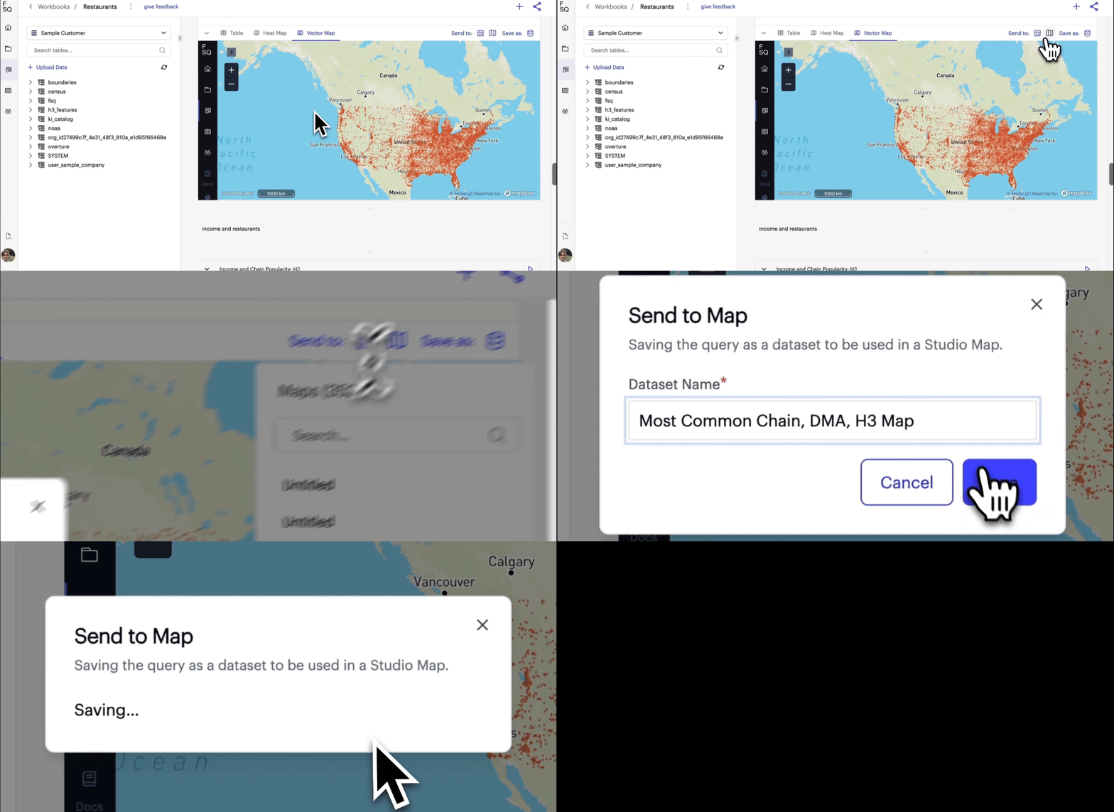
This seamless integration enables organizations to transform location data into actionable insights in hours instead of months. Whether you’re optimizing site selection, analyzing trade areas, or understanding consumer patterns, the Foursquare Geospatial Intelligence Platform provides the connected data, specialized compute, and visualization capabilities needed to make better location-based decisions — all through familiar SQL.
The Foursquare Geospatial Intelligence Platform is now available to test in beta.


