
Raster Layer
Raster layers are used to show satellite and aerial imagery. They allow you to work interactively directly with massive, petabyte-scale image collections stored in Cloud Optimized GeoTIFF format.
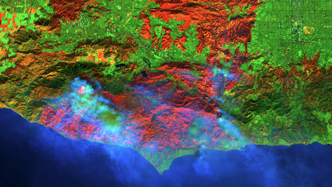
An example of the Raster Layer.
Add a Raster Data Source
To create a raster layer you need to add to a raster data source from the Data Catalog, such as Sentinel, Landsat etc.
When data is added, you can choose +Add New Layer and choose Raster Tile. The raster layer offers a number of parameters displaying the raster data.
Inside raster layer settings preset, mosaic, rescaling, gamma contrast, sigmoidal contrast, sigmoidal bias, saturation and opacity settings are available.
Time Selection
If images covering multiple time ranges are present in the data source, you can select the time range you are interested in. An important use case for the time selector is to create two layers referencing the same raster tile data source, where each layer shows a different time. These layers can then be compared using the Studio Swipe of Side-by-Side modes.
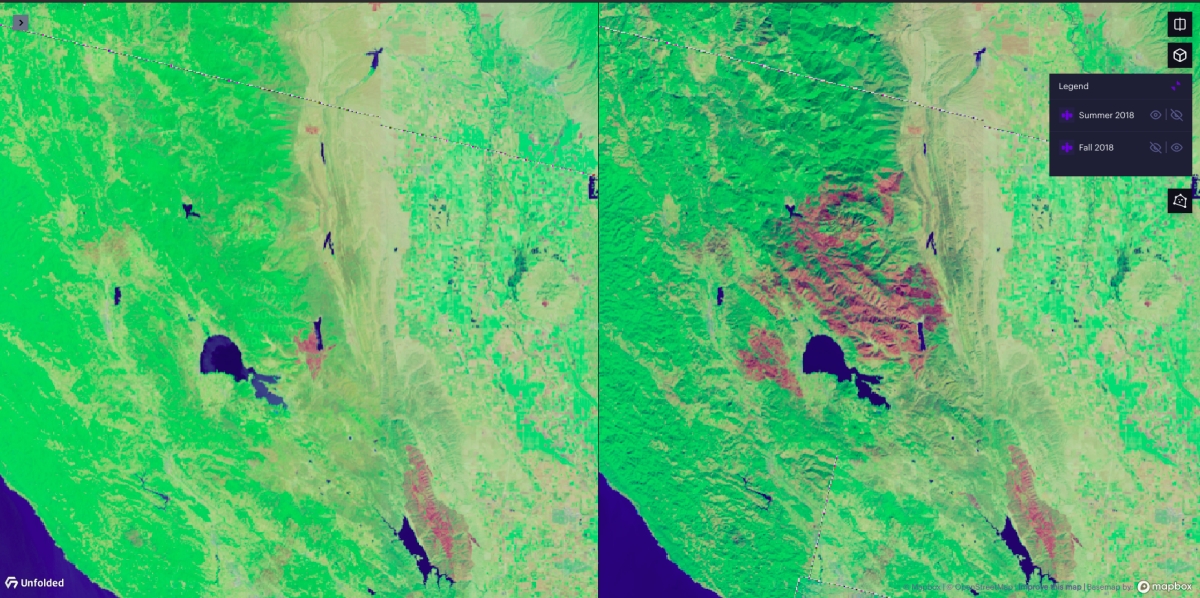
Raster Layer dual view.
In the image of dual map view from above, ‘Landsat’ is used for Data Source and ‘Forest burn’ is used for Preset. Map on the left is a map from Summer 2018 while the right map is from Fall 2018. The impact of forest fires that occurred in late summer 2018. In California are clearly visible in this example above. By combining different datasets and presets more examples can be made.
Raster Rendering Options
Studio currently supports the following set of rendering options.
Note: The strings mentioned in the "required bands" column reference definitions from the STAC
eoextension's list of common band names.
| Rendering Option | Required Bands | Description |
|---|---|---|
| True Color | 'red', 'green', 'blue' | True color. |
| Infrared | 'nir', 'red', 'green' | False-color infrared composite. Near-infrared, red, green mapped to RGB. |
| Agriculture | 'swir16', 'nir', 'blue' | False-color agriculture composite. Short-wave infrared 1, near-infrared, blue mapped to RGB. |
| Forest Burn | 'swir22', 'nir', 'blue' | False-color forest burn composite. Short-wave infrared 2, near-infrared, blue mapped to RGB. |
| NDVI | 'nir', 'red' | Normalized Difference Vegetation Index |
| SAVI | 'nir', 'red' | Soil Adjusted Vegetation Index |
| MSAVI | 'nir', 'red' | Modified Soil Adjusted Vegetation Index |
| NDMI | 'nir', 'swir16' | Normalized Difference Moisture Index |
| NBR | 'nir', 'swir22' | Normalized Burn Ratio |
| NBR 2 | 'swir16', 'swir22' | Normalized Burn Ratio 2 |
| Single Band | Any | Allows the user to view any individual raster band available in the dataset. |
Custom Raster data
Raster layers can reference user-provided, custom Cloud-Optimized GeoTIFFs (COG) by providing standardized Spatio-Temporal Asset Catalog (STAC) metadata.
Open 'Add Data to Map' dialog, chose the 'Tilesets' tab and inside 'Tilesets' tab select 'Raster' Tile. Enter a URL to a STAC metadata file into the 'Tileset metadata' field and click on 'Add Data' button to add the new dataset. For more information see Tiled Datasets and raster-specific metadata requirements below.
STAC metadata requirements
- The metadata file must be a valid STAC Item, version 1.0.0 or higher. STAC Collections and Catalogs are not currently supported.
- Raster data referenced in STAC assets should be Cloud-Optimized GeoTIFFs and need to be publicly accessible via HTTPS.
- STAC item must have Electro-Optical and Raster extensions, and at least one asset must have both
eo:bandsandraster:bandsinformation.common_namemust be provided ineo:bandsanddata_typemust be provided inraster:bands.
STAC Searching
Studio currently supports STAC searching for the Sentinel 2 STAC collection.
To use STAC searching, follow these steps:
1. Click the Use Stack Searching toggle.
2. Select a STAC Search Provider. By default, Studio will select the first available provider.
3. In the Date Range box, provide a start date and end date in YYYY-MM-DD format.
Settings
The following sections detail every setting available for the Raster Layer.
Basic
Core settings for the Raster Layer.
| Setting | Description |
|---|---|
| Layer Selection | Must be Raster Layer to display raster data. |
| Dataset | The raster dataset to use for the Raster Layer. |
Image Selection
Settings related to the image selection for the chosen dataset.
| Setting | Description |
|---|---|
| Preset | The image preset to use for the Raster Layer. Note that the available presets depend on the bands present in your dataset. Select "Single Band" to view an individual band. See above. |
| Single Band Name | (When the Single Band preset is selected) The name of the single band to view. |
| Use STAC Searching | For supproted datasets, enable STAC searching. See above. |
Visual Settings
General visual settings related to the Raster Layer.
| Setting | Description |
|---|---|
| Opacity | The opacity/transparency of the layer. |
| Colormap | The color mapping service to use. Supports all default rio-tiler colormaps as a one-word, lowercase string with underscores for spaces. |
Rescaling
Rescaling settings for the Raster Layer.
| Setting | Description |
|---|---|
| Dynamic Color | Whether to use dynamic color scale optimized for raster tiles within the viewport. For example, when viewing a "bright" spot on earth (such as ice caps or sandy deserts), the color scale will automatically adjust to best display Earth's features. |
| Non-linear Rescaling Toggle | Whether to use non-linear color map rescaling. When enabled, the below gamma and sigmoidal options can be customized. Only available on certain band combinations, such as true_color or infrared presets. |
| Gamma Contrast | The factor by which gamma is applied to the dataset. Gamma affects the degree of light applied to the dataset, changing how bright the landscape appears. |
| Sigmoidal Contrast | A factor by which to apply sigmoidal contrast. Sigmoidal contrast is a type of contrast control that adjusts the contrast without saturating highlights or shadows. Effectively enhances the intensity differences between the lighter and darker elements of the image. For example, 0 is none, 3 is typical and 20 is a lot. |
| Sigmoidal Bias | A factor controlling the level for the contrast function to center on. Must be a float between 0 and 1. Typically centered at 0.5 |
| Saturation | Adjust the saturation of colors on the map. 0 is black and white, while 2 doubles the intensity of color values. |
Filter
Filter settings for the Raster Layer.
| Setting | Description |
|---|---|
| Filter Toggle | Whether or not to apply a filter to the map. When enabled, only displayed data in a given range. |
| Filter | The range by which to display raster data. All values falling outside the range are hidden from the map. |
Terrain
Terrain settings for the Raster Layer.
| Setting | Description |
|---|---|
| Enable 3D Terrain | When enabled, render raster tiles in 3D. 3D view must be enabled. |
JSON Schema
For details on how to programmatically specify layer properties, refer to the Layer Configuration specification.
Updated 3 months ago