
QGIS
The Studio platform integrates with QGIS through the Unfolded/Studio QGIS plugin.
The plugin enables export of QGIS maps with vector layers into a format that can be imported into Studio for further analysis or one-click publishing to the web.
The Studio QGIS plugin is a standard QGIS plugin that can be installed into QGIS using the QGIS plugin management menu.
The Studio QGIS plugin can only be installed on QGIS v3.16 or later. Please upgrade your QGIS installation if the plugin does not show up in the QGIS plugin manager.
Using the Studio QGIS plugin.
More information is available in the blog post.
Installation
The Plugin is registered in the official QGIS plugin repository and it can be installed directly from QGIS, via Plugins > Manage and Install Plugins.
Note that the plugin requires QGIS version 3.16 or above.
Usage
The following sections explain the functionality of the plugin in detail. The plugin is designed to be simple and intuitive, especially for people with prior experience with QGIS.
Preparing a map in QGIS
Before opening the plugin, users add their datasets to QGIS in the normal way (see e.g. QGIS tutorials), perform data processing tasks if necessary and add cartographic styling for the vector layers.
Exporting the map from QGIS
After the user is satisfied with their QGIS map and the plugin has been installed, the Unfolded/Studio Map Export plugin can now be opened under the Web tab in QGIS or by clicking the Studio icon. This opens a new window, which lets the user control the map export process.
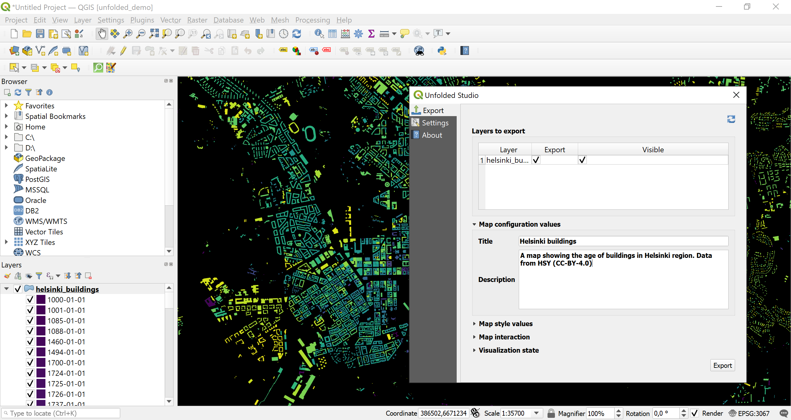
Main export dialog
-
Layer to export - If the QGIS project contains multiple layers, user can select which layers should be exported and which should be visible by default (note layers are preserved in the exported map and the user can control layer visibility in Studio after importing the map). Layers are exported with the same name as they have in the QGIS project.
-
Map configuration values - If the QGIS project is saved with a specific name, it will be read automatically as the export file name. This will be shown as the default name in the exported map. It is also possible to write description of the map which will be shown in Studio.
-
Map style values - Here user can select which type of basemap they want to use in Studio. The styles listed are the ones available by default in Studio.
-
Map interaction - Which Studio functionalities (e.g. brushing, geocoding) the exported interactive map should offer.
-
Layer blending - How overlapping features should be shown in the interactive map. In QGIS similar effects can be tested by changing feature blending modes.
Settings
In the Settings tab user can define where they want the exported configuration file to be exported on their local disk. Layer geometries and styles are exported in to a single configuration file, which can then be imported to Studio. User can define the output file format in the Settings tab.
A user can also add their personal MapBox API key if they wish to add MapBox basemaps to their project. By adding a key and clicking Add WMTS basemaps, a user gets the standard basemaps in their project. This can be helpful e.g. in making the color choices just right to work in Studio. In this tab a user can also define the logging level mainly for development purpose.
From the About tab a user can see the basic information about the version they are using and find relevant links.
Supported data and coordinate formats
Any vector data format that is supported in QGIS can be exported, and the data can be in any known coordinate reference system as it is automatically reprojected (to EPSG:4326) during export.
Supported projections, styling and layer types
Currently the plugin supports exporting line, point and polygon geometries. Both multigeometries and single part geometries are supported.
The cartographic capabilities in QGIS are vast and can become very complex, and currently the plugin supports only basic styling. From a styling perspective QGIS and Studio can complement each other: a style started in QGIS can be fine tuned further in Studio. The following QGIS styles are currently supported:
- Single Symbol with Simple Fill - These are the basic QGIS styles. With these you can define a fill and a stroke styles (width and color) for a feature.
- Categorized - With categorized styling you can visualize qualitative data. The color palettes used in QGIS visualization are automatically exported.
- Graduated - Graduated styling can be used for sequential or diverging datasets. Currently supported classifications are quantile and equal interval.
Importing to Studio
A file exported with the plugin can be imported to Studio. After signing in to Studio, Import Map button can be found under the Maps tab. From there a user can browse to the export file on their local machine and click on Import. This creates a new map under their account and uploads the included dataset(s) for the user. This map can then be further modified in a normal manner in Studio and published.
Support
The #gqis-plugin channel on the Community Slack is dedicated to the QGIS plugin and lets you interact with developers and the community.
You can also reach out to us directly at [email protected].
Contributing
The Studio Map Export QGIS Plugin is open source and licensed under a permissive GPLv2 license. If you encounter a bug or would like to see a new feature, please open an issue. Contributions are welcome. Refer to development for notes on how to work with this QGIS3 plugin.
Updated 4 months ago